The Old World
About Me
- Elias
- Born in Nashville, grew up in Philly. Now I'm sort of all over the place.
Friday, January 6, 2012
Sunday, December 11, 2011
Monday, December 5, 2011
Using ArcMap 10 to Conduct On-Screen Digitizing Strip Mine Impacts to Land Cover
Hello hypothetical future interns,
Welcome to a fight for environmental justice. In this battle, we are going to replicate the technical analysis that the West Virginia Department of Environmental Protection should be doing for watersheds impacted by mine activity.
This blog entry will explain the process I am using to interpret the impacts of strip mining on land cover typology from aerial photographs. Eventually, this methodology will be applied to the mrSID aerial photography from 1996 (seen below) and then to ortho-adjusted aerial photography from 2009 (the greener images below). Once the impact areas for 1996 and 2009 have been delineated and drawn as vector data, we will then be able to approximate a measurement of acreage disturbed in each era and then compare the change from 1996 to 2009.
I have begun the process for Elkhorn Creek Watershed for the mrSID 1996 aerial photography. This watershed can be seen in the lower right hand corner of Map 1. Our other two study areas are Pigeon Creek Watershed and Laurel Creek Watershed.
Map 1:

Were this phase of the work happening as part of a doctoral thesis, or if our aggregate study area was smaller, we would use a more complex process called remote sensing to track the number of pixels that change color from year to year, and use this to approximate the amount of land cover disturbed due to strip mining.
As shown in Map 2, various land cover types that have unrelated causes would be conflated together were we to use remote sensing without first delineating vector masks of probable mining areas. By now you should have read the article that I shared "Changes In the Extent of Surace Mining and Reclamation in the Central Appalachians Detected Using a 1976-2006 Landsat Time Series.pdf" to show an example of how remote sensing can be best applied for this purpose. However, we are able to interpret this aerial photography manually with more precision, and this is shown in Map3.
Map 2:

Map 3:

Eventually, we will be doing this same process of delineating areas of mining impact for "leaf-on" aerial photography from 2009. At this point in the process we are going to have to reassess how we digitize areas where there has been land cover change, and use the shapefiles we've already created and contemporary mine permit boundary data to guide us.
Map 4 illustrates the scrutiny which will be necessary at times to make sure that we are being conservative enough in our interpretation of land cover disturbances due to mine activity.
As I've noted in the text bubbles, the two areas showing buildings are adjacent to heavy mine activity. However, in comparing the photography from 1996 and 2009 I noted that although increased mining activity was showing impact on the road, it didn't seem to show any impact on the two other open areas. So, even though they may be mine facilities (offices) I did not classify them as land cover disturbance related to mine activity. The road, while not drawn on these example images, would be drawn in the final map.
Map 4:

Map 5 shows an inadequate approach to digitizing areas of mine disturbance. If we only select out the areas that are shown as rock or gravel, we lose the areas that are green but are in fact what are classified as "reclaimed pasture" in the article that I shared with you. That article, and many others make clear that these areas need to be identified, because although they show vegetation they do not have run-off characteristics like true pastures.
Map 5:

Although not as large or easy to draw, it is still important that we account for the impact of contour mining and mine haul roads on local hydrology. Maps 6 through 8 show the approach I am using to digitize these areas. Note that on Map 3 the entire road north of the area marked "Area of Mining Impact" would need to be drawn. Map 8 shows only a work in progress for the area shown; in the final map the entirety of what I interpret to be impacts from contour mining would be drawn.
Map 6:

Map 7:

Map 8:

However, as this work has progressed I have identified a problem with this approach. Because the 1996 mrSID aerial photography is "leaf-off" it is much easier to fully identify and draw the impacts from contour mining and haul roads. In the 2009 ortho-adjusted aerial photography the surrounding foliage makes identifying areas likes this almost impossible in some places. Map 9 illustrates this problem. I have drawn what appear to be mining disturbances in the earlier photography, but cannot reliably do this in the later photography. Were the earlier photography "leaf-on" also it is not clear that I would be able to draw these mine disturbances. This differing level of precision in each set of photography may have an impact on the accuracy of the eventual comparison.
Map 9:

In suggesting that this is a problem I do not question the impact on local hydrology of narrow but ubiquitous contour mining disturbances or haul roads. Instead, I question whether a reasonable comparison can be made between the two types of aerial photography if two types of mine disturbances are left out of the later measurement. One possible solution to this problem would be to adjust what we are measuring. Instead of a vector-based measurement of land cover disturbances due to mine activity, we are measuring land cover disturbances due to mine activity for clear cutting, area and high wall mining and major haul roads.
Thanks for reading! Any suggestions are greatly appreciated and should be sent to eschewel(at)umich(dot)edu.
Saturday, June 4, 2011
How to Make an Oven: Bronze Age Edition
I'm living in West Virginia now, but since this is my weekend with a good, strong internet connection (I'm at my grandparent's house in Lynchburg, VA) I thought I'd catch up on some photoblogging that I had meant to do before departing for the rural reaches that will be my home for most of the summer.
In the last year I've gotten into a mild habit of killing, cleaning and then BBQ'ing farm animals. Since I got some good pictures of the process this year, I thought I'd make a little step by step. The basic idea here is that you're starting a large fire over some rocks, and letting all that energy from the fire become embedded in the stone. Then, you put the fire out and let the heat slowly escape from the rocks and roast your meat.
Step 1: Gather the Basics

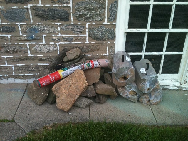
Here we see a bunch of flat rocks from a local creek bed, firewood, burlap, a spool of wire. What's missing from the picture is a shovel, aluminum, and of course newspaper and some matches. And the meat you plan to cook.
Step 2: Dig a Hole

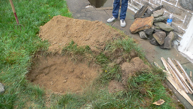
Self explanatory. Notice the kindling that we've started to gather on the right side of our hole. Keep the excavated dirt handy - you're going to need a bunch of it later.
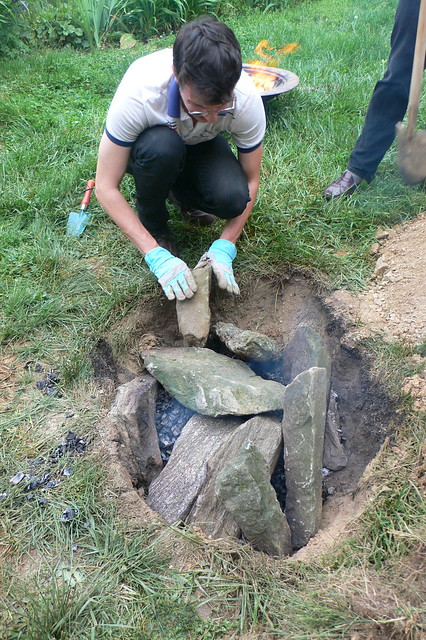
Step 3: Line the Hole with Rocks

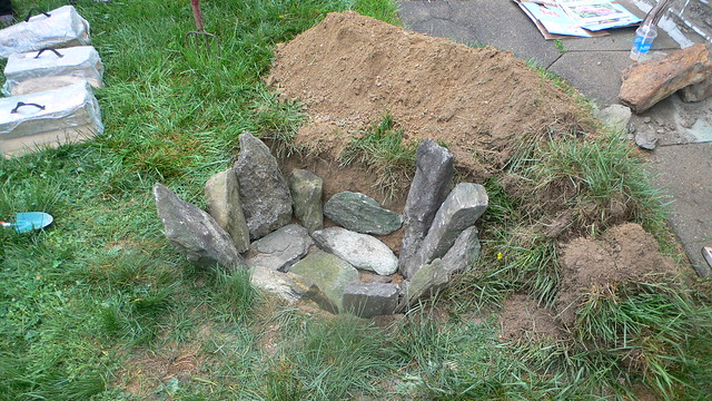
It's best to get your biggest, flattest rocks on the bottom of the hole. This makes a nice simple shelf for your meat and coals to sit on later. Also, heat rises of course and so the more of the mass to be heated you can place at the bottom the better.
Step 4: Start a Massive Fire in the Hole

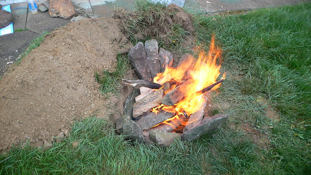
One thing I've learned from doing this is that you only get one chance to build your fire, so build it as big as you reasonably can. If you build a fire, and realize halfway through that it's not going to give you enough coals you can't easily change your course by throwing more logs on. As the new logs finally burn down to hot embers the coals from the first round will already be turning to ash. Go big the first time, and if you're cooking meat with enough fat in it you have little to worry about.
Step 5: Prepare Your Meat

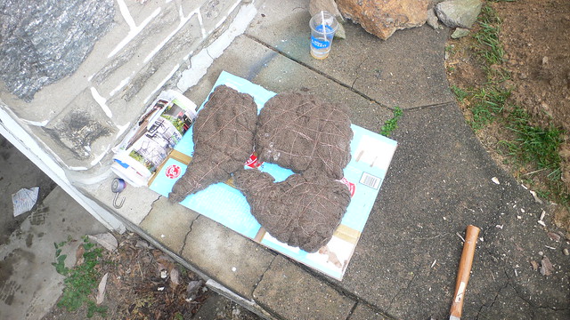
In the photo above you can see two lamb shoulders and 4 lamb necks wrapped first in aluminum foil, and then in wet burlap. It's important to make sure the meat is well-wrapped, but don't go overboard as you can shield the meat from getting the fullest roast possible (the kind that makes the meat fall off the bone). Again, if you've built a massive fire (see above) you shouldn't have to worry about not cooking the meat fully.
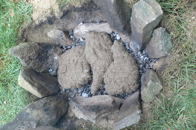
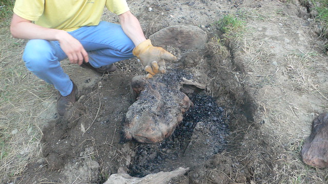
Step 6: Dig Out the Coals and Place the Meat

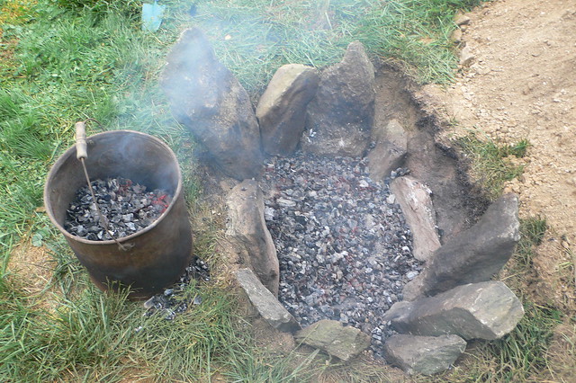
Have a bucket handy into which you shovel as much of the coals as possible. A wheelbarrow also works, or a big metal pot. Then lovingly place the meat you will be cooking into your primitive stone oven (notice that it's pretty impossible to get all the coals out, and being that precise doesn't matter in backyard BBQ'ing).

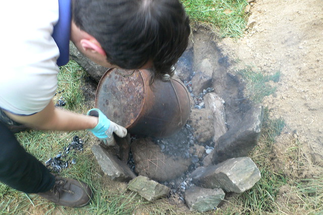
Step 7: Bury the Meat
A) Pour the coals back in . . .

B) Push all your rocks in on top . . .

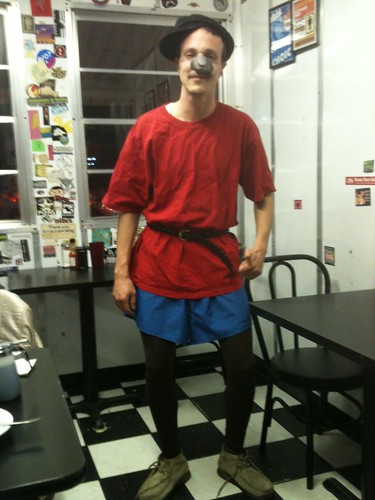
C) Make your well-dressed friends put the dirt back on . . . (note Ethan's loafer top left)

Step 8: Unwrap and Enjoy
Unfortunately, I seem to have stopped taking pictures once the lamb was in the ground.
Using this method, a full lamb takes seven hours to cook. For the two lamb shoulders and the 4 lamb necks I did it for half as long, pulling the pieces out after three and a half hours. I suggest using wire cutters to get into your succulent and still-wrapped meat, and doing the unwrapping outside. It will end up dropping ash, charred burlap and dirt all over the place.

(photo from last year)
Any questions? Mr.Schewel(at)gmail(dot)com
Wednesday, March 30, 2011
For Akasha
My friend Akasha lives in New Orleans and is opening a thrift shop. She has a lot of cool clothes laying around, and gave me this gnarly felt hat when I was down there in March. However, there was one condition: I had to put a picture of me wearing it up on the Internets somewhere. So here you go, Akasha.

There are a couple different styles to it. Here's an alternate:

It's almost an LL Cool J throwback but not quite.

If you don't know me, and don't know Akasha and think this is stupid I suggest you watch this video about "search and rescue teams" from Japan that are combing the wreckage for family photos.
Saturday, December 25, 2010
Sunday, December 19, 2010
Howl
Tomorrow I begin the long journey through the windswept landscape of eastern Ohio and western Pennsylvania. Departing Ann Arbor for the first time as a student, I want to take a moment to showcase those beings that made this semester special. No, not people - just the crazy animals who help me keep everything in perspective. When you spend too much time in a library you start to feel like a robot, but I am also just an animal despite my opposable thumbs, reliance on caffeinated beverages, proficiency in computer-based spatial analysis and love of alternative country music.


FELIPE - who has no idea where or what he is


Let's howl
KIRA - who is a mighty hunter


FELIPE - who has no idea where or what he is


Let's howl
Saturday, November 20, 2010
11 Seconds In The Microwave
"Nardwuar equals dumb silly name, like Sting; Human means human, as in Human Fly; and Serviette is something you can't get in the U.S. because down there they're called napkins."
This guy, a musician and radio host from Vancouver, legally changed his name to "Nardwuar the Human Serviette." This is a great interview, and I particularly like the subtle hostility and insistence he brings to the Doggfather. Snoop also seems a little confused as to how to pronounce the name of his interviewer. Note: it doesn't rhyme with hard.
Here's the Gourds' cover of "Gin and Juice."
Tsar or Czar
I can't resist stealing from the Huffington Post, these photos are too good. Taken by Sergei Mikhailovich Prokudin-Gorskii between 1909 and 1915 they document the Russian Empire.


Is it kinda toy to just jack photos from the Huffington Post? I don't think so.

Thursday, November 18, 2010
I'm So December 19th Right Now
Tuesday, November 16, 2010
Tent Variance
On a completely unrelated note, here is an aerial shot of that time when Muammar el-Qaddafi was attending the United Nations Summit, and tried to rent Donal Trump's estate in Upstate New York but was banned by the Westchester County town of Bedford, NY.
Making Love to the Camera
I use Google Maps to locate destinations like most people. Sometimes I have been so bold (bored?) as to use Google Streetview to undertake some digital tourism of places I'll probably never visit, such as this urban park in Bangkok, Thailand. What can I say? I found a tourist map of Bangkok in a pile of freebies on a stoop in Brooklyn, and being drawn to this enormous green gem on the map I decided to take a "drive" around.
Google Streetview was launched on May 25th, 2007 and since then has come to document the streets and sidewalks of many cities around the globe. I've seen all kinds of weird shots of street life before, but now Jon Rafman has created a Tumblr account displaying what have got to be some of the weirdest vignettes of all time.
Monday, November 15, 2010
Video Title Below
Can't say enough about the Tony Castles. Buy the album - show some love.
ALSO, TOO:
Find more artists like (THE) TONY CASTLES at Myspace Music
Sunday, November 14, 2010
There Are No Cats in America
I'm prone to polemic and addicted to politics, so in creating a blog I wanted to avoid political commentary. There are other people out there for that, and they do it much better.
"I don't know how the laws of economic physics break down at our shores. They don't!"
"It got to be so bad, that if you actually tried to leave the Empire of Rome, they would kill you."
I present you this Glenn Beck video as spectacle, and spectacle alone. Whatever you think of this man's agenda, there can be no doubt that he is an amazing performer. Below the video I've pulled out some of the more stunning and vapid quotes.
"I'm not doing this to scare you, I'm doing this to break your mind apart."
"I don't know how the laws of economic physics break down at our shores. They don't!"
"It got to be so bad, that if you actually tried to leave the Empire of Rome, they would kill you."
I picked the quotes that we can laugh at together. I don't have time to pull out the quotes that are filled with deeply coded hate and fascistic political dog whistles.
Much has already been written about the blatant and classic antisemitism that Beck is utilizing in attacking George Soros. I'll just post this screenshot of The Jew talking to the Devil from the Beck segment.
Wednesday, November 10, 2010
Monday, November 8, 2010
Halloween Costume, 2020
I first got into Francis and the Lights when a friend invited me to attend an intimate acoustic show he did at Joe's Pub in NYC. There's no music like melancholy music. One day he'll be famous enough that I can dress as him for Halloween.
Sunday, November 7, 2010
Release!
After maintaining a Facebook page since 2004, I have just tonight deleted my user account. It feels amazingly liberating. Now if people want to interact with me they have to program their robot butler to send me a text message or they can @ me on Twitter.
The aftershock hit me in a matter of minutes - two text messages asking me if I was serious. I don't say that to toot my own horn, but instead to comment on how integrated social activity is with that website.
And this shit is just creepy:
The aftershock hit me in a matter of minutes - two text messages asking me if I was serious. I don't say that to toot my own horn, but instead to comment on how integrated social activity is with that website.
What I quote next should not be taken as a value judgement of the participation of others on Facebook. I was highly involved for many years, and know what fun and happiness can come out of it, but I just don't think it's for me anymore.
"When a human being becomes a set of data on a website like Facebook, he or she is reduced. Everything shrinks. Individual character. Friendships. Language. Sensibility. In a way it’s a transcendent experience: we lose our bodies, our messy feelings, our desires, our fears."
- Zadie SmithI am not so naive that I think that people who interact with me in real space don't also reduce me, as I reduce them, by dress, gender, class, mannerisms, race and geographic origin. However, if we become friends we are inherently moving out of this world of reductionism. On Facebook, I can be "friends" with someone for years and only harden their reduced understanding of who I am. Indeed were I to try to provide more and more context for a comment or post I just made the value and interest in that post would fall of a cliff. No thanks.
Oh, and if you would like to make value judgements on current users of Facebook please follow this link.
And this shit is just creepy:
Sunday, October 31, 2010
Saturday, October 30, 2010
Need Some Sunshine?
I made a map of Philadelphia, for anyone thinking of visiting. It's incredibly personal, and I only present it as such: "this is my favorite stuff in my hometown." Get at me if you're headed there and you have any questions.
View A Map of Philadelphia for Visitors in a larger map
From Here, the Future Looks Bright

Doing some bike exploring in the sterile, steely Martian landscape of the University of Michigan Research Campus.
Friday, October 29, 2010
Thursday, October 28, 2010
Friday, October 22, 2010
"I am a pick-up truck. I am America"
The title and relevant line is at 1:30 in the new Das Racist video.
You know how I feel about America, and what I think pick-up trucks represent.
Musically I can't give much love to Das Racist, but the social commentary and racial humor throughout their songs is definitely always on point.
"The white man can't even go outside, he gets a disease. I'm talking about how white people can't even go outside without getting a disease."
Monday, October 4, 2010
Ownership Society: "You're on your own!"
Fire protection services are non-rival, but citizens are easily excluded.
Friday, October 1, 2010
The chicken traditionally falls off the bone

This past summer I helped move my grandparents out of their house into a new place on the grounds of an assisted living facility. Helping them pack up, I got to take some awesome family heirlooms with me. This cast-iron, porcelain coated braising pot was my grandmother's (she's still alive, but she gave me the pot). She writes this about the pot: "In about the 1960's those heavy enamal covered pans got very popular. I used that one a lot for parties for you mom and your uncles' friends . . . spaghetti, casserole dishes, etc. I used it a lot at one time particularly for informal and outdoor gatherings." This was the first time it's been used in awhile. Those are teeny potatoes provided by Trader Joe's for $1.99.

Sunday, September 26, 2010
Study hard if you want to change this world
Surveying the landscape it seems to be an uphill battle.
Friday, September 24, 2010
Thursday, September 23, 2010
"I'm the warden. Welcome to Super Jail"
Sometimes I don't actually get Adult Swim shows enough to warrant sitting through one. I feel very differently about Super Jail.
[it's like Bruce Bickford, R. Crumb and Todd McFarlane all rolled into one]
[it's like Bruce Bickford, R. Crumb and Todd McFarlane all rolled into one]
I watched the sun set in NYC today, from Michigan
Subscribe to:
Posts (Atom)


